Lake Michigan contains no saltwater.
No ocean tides in the ordinary sense.
No connection to the sea that matters to the person standing on the beach.
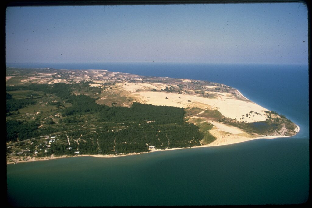
Then you reach parts of the shoreline and find hundreds of feet of sand rising above freshwater.
Sleeping Bear.
Grand Sable.
Massive coastal dune systems more visually associated with deserts or oceans than with Michigan.
The lake is not pretending to be an ocean.
The geology is simply using ocean-sized ingredients.
Start With Ice
The dune story begins with glaciers.
Continental ice repeatedly reshaped the Great Lakes region during the Pleistocene.
Glaciers excavated basins, moved sediment and left enormous deposits of sand, gravel, clay and rock.
At Sleeping Bear Dunes, many of the high coastal landforms beneath the sand are glacial moraines.
These are ridges or masses of sediment left by glacial ice.
When the ice retreated, the raw ingredients for future beaches and dunes were already everywhere.
The dunes are not simply piles of modern beach sand sitting on flat ground.
Many are sand layered over older glacial topography.
This is why some of them become so absurdly tall.
Then the Lake Starts Sorting
Waves attack the glacial bluffs.
Erosion releases sediment.
Water sorts that sediment by size and weight.
Heavier gravel tends to remain lower.
Sand is moved along shorelines and onto beaches.
Then wind takes over.
Dry sand from beaches and exposed bluffs can be blown inland.
Vegetation, slopes and topography trap it.
Dunes grow.
NPS describes the Sleeping Bear system as the product of continuing interactions among glacial deposits, waves, wind and vegetation.
The lake supplies material.
The atmosphere rearranges it.
The plants attempt to hold it still.
Nobody wins permanently.
Perched Dunes Are the Show-Off Version
Some of Michigan’s most dramatic dunes are perched dunes.
These sit on top of existing high bluffs or glacial moraines.
At Sleeping Bear, the underlying bluff can already be hundreds of feet above Lake Michigan.
Then wind piles additional sand on top.
This is how visitors end up looking down from something that feels like a mountain made of beach.
NPS says Sleeping Bear’s dunes and bluffs can rise about 450 to 460 feet above the lake.
Grand Sable Dunes at Pictured Rocks rise more than 300 feet above Lake Superior.
The dune did not grow 400 feet upward from a normal beach in one step.
It began with elevated glacial terrain.
Then Michigan added sand.
The Dunes Move
Dunes are not fixed structures.
Wind erodes one side and deposits sand on another.
Vegetation can stabilize surfaces.
Storms can strip plants and reactivate movement.
Lake-level changes expose new sand or allow waves to attack bluff bases.
At Sleeping Bear, the famous Mother Bear dune has changed dramatically over time.
NPS interpretation describes long-term erosion caused by wind, waves and historical human disturbance.
The dune once maintained a much more recognizable bear-like form.
Now it is migrating and eroding.
A landmark made of loose sand has declined to remain landmark-shaped.
This should not be surprising.
We are the ones who gave it a noun.
Falling Dunes and Sand Avalanches
When sand accumulates on steep slopes, gravity joins the process.
Small slides and larger slope failures can move material downhill.
At bluff edges, wave erosion may remove support from below.
Wind moves material from above.
The profile adjusts continuously.
This means the dunes can look stable at human timescales while still changing measurably across decades.
A forest may grow over a dune and make the entire landform appear permanent.
Under the trees:
still sand.
The forest has rented.
Lake Levels Have Changed Before
The Great Lakes have not always occupied exactly their modern shorelines.
After glacial retreat, drainage routes changed.
The crust rebounded after removal of the enormous ice load.
Water levels rose and fell.
Earlier lake stages created shorelines at different elevations.
NPS notes that some older dunes at Sleeping Bear formed during higher postglacial lake stages.
So the dune landscape includes several versions of Lake Michigan layered together.
Former beaches can now sit inland.
Former lake edges can become forested ridges.
The shoreline is a moving boundary pretending to be a line on a map.
Freshwater Does Not Mean Small Water
Lake Michigan is enormous.
Wind blowing across a large water body builds waves.
Those waves transport sediment.
The lake’s size also affects local weather and wind patterns.
From the beach, the horizon can look marine because the far shore is invisible.
The same physical scale helps explain how a freshwater lake can support major coastal geomorphology.
There is no rule requiring a dune to verify salinity before becoming impressive.
Sand needs:
- sediment supply;
- wind;
- space;
- and time.
Michigan has all four.
Plants Hold the Place Together
Dune grasses and other vegetation slow wind near the surface and trap moving sand.
Roots stabilize dunes.
As dunes become more stable, shrubs and trees can establish.
Ecological succession transforms open sand into increasingly vegetated landscapes.
Disturbance can reverse the process.
This makes dunes both geological and biological systems.
Walk off designated trails repeatedly and vegetation can be damaged.
Lose enough stabilizing cover and sand begins moving again.
The apparently empty sand surface is part of a living system with limited tolerance for millions of feet.
The Human Story Is Also There
Sleeping Bear Dunes is culturally important to Anishinaabe peoples.
The Mother Bear story is part of Anishinaabe oral tradition and gives the landscape a meaning far older and deeper than the modern recreation industry.
NPS interpretation presents multiple versions of the story and notes the longstanding use of the dune as a landmark.
This matters because geology articles have a tendency to begin with the Ice Age and accidentally erase everyone who lived there afterward.
The dunes are landforms.
They are also homelands.
The two facts occupy the same sand.
Showing Off
Michigan does not have desert dunes despite looking like it does.
It has glacial coastal dunes.
That distinction explains almost everything.
Ice supplied enormous sediment deposits.
Lakes and waves exposed and sorted them.
Wind transported sand.
Old moraines provided height.
Plants stabilized some areas.
Erosion reactivated others.
The result is a freshwater shoreline with dunes tall enough to make the lake below look impossibly far away.
Calling this “the Great Lakes showing off” is scientifically unhelpful.
It is emotionally accurate.
Related: The Great Lakes Are Large Enough to Manufacture Weather · The Driftless Area: The Part of the Midwest the Glaciers Somehow Missed · The Great Basin Is Hundreds of Basins and None of Them Know Where to Go
Leave a Reply