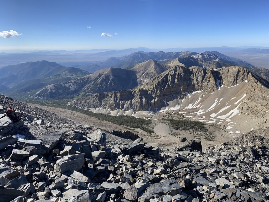
The Great Basin sounds like one object.
A basin.
Large.
Simple.
Perhaps somewhere near Nevada.
This is false in nearly every useful way.
The Great Basin is a vast region of mountain ranges, valleys, dry lakebeds, salt flats, rivers that do not reach the sea, and drainage systems that terminate internally.
It is not one bowl.
It is a collection of bowls, pans, sinks, playas, valleys and enclosed watersheds extending across much of Nevada and significant parts of Utah, Oregon, California, Idaho and Wyoming.
The name is singular.
The plumbing is not.
Start With the Water
The most common definition of the Great Basin is hydrographic.
National Park Service material describes the hydrographic Great Basin as roughly 200,000 square miles of internally drained land.
Rain and snow fall.
Water moves downhill.
Then, unlike most major North American drainage systems, it does not eventually reach the Pacific Ocean or Gulf of Mexico.
Instead it:
- evaporates;
- sinks into the ground;
- or terminates in inland lakes and playas.
This is called endorheic drainage.
The water is trapped by topography.
It does not know where to go because the answer is:
nowhere else.
The Great Salt Lake Is the Famous Example
The Great Salt Lake occupies one of these terminal basins.
Water flows in.
No river flows out to the ocean.
Evaporation removes water but leaves dissolved minerals behind.
Over time, salts concentrate.
This basic mechanism also explains many playas and saline lakebeds throughout the region.
A closed basin keeps receipts.
Every dissolved mineral entering with water has limited ways to leave.
The water disappears into the sky.
The salt stays.
Basin and Range Is the Shape Underneath
The larger geologic setting is the Basin and Range Province.
The crust has been stretched.
Blocks of crust dropped down along faults to form valleys.
Adjacent blocks rose or tilted to form mountain ranges.
The result is a repeated pattern:
mountain,
basin,
mountain,
basin,
mountain,
basin.
Drive across Nevada and this becomes physical.
You cross a flat valley floor.
Climb a mountain pass.
Descend into another valley.
Repeat until your sense of distance stops working.
The Great Basin is not empty.
It is rhythmically inconvenient.
Definitions Do Not Match Perfectly
This is one reason the term causes confusion.
There is:
- the hydrographic Great Basin;
- the broader Basin and Range geologic province;
- ecological definitions;
- cultural and historical uses of the name.
These overlap.
They are not identical.
Great Basin National Park itself occupies one small portion of the larger Great Basin region.
You can therefore stand inside Great Basin National Park while looking at a Great Basin landscape inside the Basin and Range Province and still not have used the terms interchangeably.
Geography is delighted with this arrangement.
Mountain Islands
The basin floors can be intensely dry.
The mountain ranges rising above them can be cool, forested and snowy.
Elevation changes climate dramatically.
A single range can contain desert shrubs low down, pinyon-juniper woodland above, then conifers and alpine environments near the top.
These isolated high-elevation habitats are sometimes described as sky islands.
To a species adapted to cool mountain conditions, the dry basin below can act like ocean between islands.
Climate change makes this geometry especially important.
Move uphill far enough and eventually the mountain ends.
The Ancient Lakes Were Bigger
The Great Basin was wetter during parts of the Pleistocene.
Large pluvial lakes occupied many modern desert basins.
Lake Bonneville covered much of western Utah.
Lake Lahontan occupied enormous areas of Nevada.
Modern Great Salt Lake is a remnant of Lake Bonneville.
Pyramid Lake and other waters are remnants of the Lahontan system.
Old shorelines remain etched on mountain slopes far above current lake levels.
This produces one of the best desert experiences:
Standing hundreds of feet above a dry valley and realizing you are at an ancient beach.
The water is gone.
The shoreline kept the address.
Dry Does Not Mean Lifeless
The Great Basin contains sagebrush steppe, salt-desert shrub, wetlands, riparian corridors, montane forests and alpine habitats.
Pronghorn cross open basins.
Sage-grouse depend on sagebrush landscapes.
Bristlecone pines persist at high elevations.
Migratory birds use wetlands and terminal lakes.
The region’s biological diversity is tied directly to elevation, water and the isolation of mountain ranges.
A place described primarily by what its water fails to do can still contain remarkably complex ecology.
Human History Predates the Name
Indigenous peoples have lived throughout the Great Basin for thousands of years and continue to maintain cultural ties to these landscapes.
Tribal nations and communities include Paiute, Shoshone, Ute, Washoe and others across different parts of the region.
The geographic phrase “Great Basin” came later.
The water did not create an empty region waiting to be scientifically defined.
It created one set of conditions within longstanding human homelands.
This matters especially in desert writing, which has a bad habit of equating low population density with absence.
Water Still Controls Everything
Modern settlement did not solve internal drainage.
Cities, farms and industry depend heavily on rivers, groundwater and snowpack in a region where water is naturally limited.
Terminal lakes are especially sensitive to changes in inflow.
Withdraw more water upstream and the lake shrinks.
Evaporation continues regardless.
Salinity rises.
Exposed lakebed can create dust problems.
Wildlife habitat contracts.
A drainage basin with no outlet makes water allocation unusually visible.
What happens upstream does not disappear downstream.
It accumulates.
Or fails to arrive.
One Great Basin
The singular name begins to make sense only at the largest scale.
Hundreds of internally draining watersheds share the same broad hydrologic fate.
Water falls inside the region.
It stays inside the region until it evaporates or enters the ground.
No grand river collects the whole thing and marches toward an ocean.
There is no Mississippi of the Great Basin.
Instead, the landscape keeps ending locally.
At a salt lake.
A playa.
A marsh.
A sink.
A patch of ground where the stream simply stops.
This is an enormous region united by failure to leave.
Geographically, that is a system.
Emotionally, it is several hundred basins that have decided not to go anywhere.
Related: Why Death Valley Occasionally Becomes a Lake · The Nebraska Sandhills Are a Desert Wearing Prairie · The Driftless Area: The Part of the Midwest the Glaciers Somehow Missed
Leave a Reply