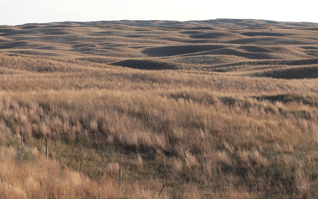
Central Nebraska contains an enormous sand-dune field.
Not ancient dunes buried under rock.
Not little dunes along a river.
Actual dunes.
Some rise hundreds of feet.
The field covers tens of thousands of square miles.
You can drive through it for hours.
Most of the sand is covered in grass.
This is why people fail to notice they are crossing one of the largest dune systems on Earth.
The desert put on prairie and became Nebraska.
Start With the Sand
The Nebraska Sandhills occupy roughly a quarter of the state.
U.S. Geological Survey material describes the dune field as about 57,000 square kilometers, or roughly 22,000 square miles.
It is the largest sand sea in the Western Hemisphere.
Individual dunes can reach more than 100 meters in height.
Those are not decorative ripples.
They are major landforms.
The difference from an active desert is vegetation.
Grasses stabilize the sand.
Once covered, the dunes stop migrating dramatically.
The dune remains.
The surface becomes ranch country.
Where Did the Sand Come From?
The sand accumulated during dry periods of the late Quaternary.
Wind moved enormous volumes of sediment into dunes.
Sources included river valleys and exposed sandy deposits.
Dune-building occurred repeatedly as climate shifted between drier and wetter conditions.
When conditions became wetter, vegetation spread across the dunes and stabilized them.
This means the modern Sandhills are not one permanently inactive fossil.
Research shows dunes have reactivated during past droughts.
Grass cover is doing continuous geomorphic work.
Remove enough vegetation under dry conditions and wind remembers what the hills are made of.
The Water Underneath Changes Everything
Here is the part that makes the Sandhills especially strange.
Under the dunes lies one of North America’s most important groundwater systems.
The Sandhills are part of the High Plains Aquifer, often broadly referred to through its Ogallala component.
University of Nebraska material notes that a very large share of the High Plains Aquifer’s stored water lies beneath the Sandhills.
The sandy soil allows precipitation to infiltrate rapidly.
Instead of running off hillsides, much of the water sinks into the ground.
The dunes therefore function like a huge sponge.
This is how a giant sand landscape can also contain wetlands.
Lakes Between Dunes
In low areas, the water table reaches the surface.
Wet meadows form.
Lakes appear.
Spring-fed streams begin.
The contrast is extraordinary.
Stand on one dune and the landscape looks dry and sandy.
Walk into the valley and your boots can be in a wet meadow because the groundwater is almost at the surface.
This is not a desert in the modern climatic sense.
The “desert wearing prairie” title is metaphor.
The Sandhills receive enough moisture to support extensive grassland.
The sand is the inherited landform.
The water is the modern system.
The Rivers Are Connected to the Aquifer
Groundwater feeds many Sandhills streams.
This produces relatively steady flow and cool water.
The Nebraska Sandhills are therefore hydrologically important well beyond their visual boundaries.
Rain falling on the dunes can recharge groundwater that moves slowly through the aquifer and emerges elsewhere.
The sand does not merely hold grass in place.
It regulates water.
This is one reason contamination and groundwater management matter so much.
Water enters easily.
That is excellent for recharge.
It also means what reaches the soil deserves attention.
Ranching Fits the Terrain
Much of the Sandhills is rangeland rather than cropland.
The steep sandy slopes and erosion risk make widespread cultivation poorly suited compared with grazing.
Native grasslands support cattle ranching across huge areas.
This has helped preserve a much larger share of native grassland than in many other Great Plains regions converted to intensive row-crop agriculture.
That does not make the landscape untouched.
Grazing intensity, invasive species, fencing, water development and land management all influence ecology.
But the relationship between sand and agriculture mattered.
The dunes made plowing unattractive.
The prairie benefited indirectly from inconvenience.
The Dunes Can Wake Up
The Sandhills have not always been stable.
Geologic evidence shows major dune movement during prehistoric droughts.
This matters as the region faces modern climate variability.
Vegetation is the primary thing holding the sand in place.
Healthy grass cover reduces erosion.
Severe drought plus heavy disturbance can weaken that protection.
The Sandhills are therefore a landscape in equilibrium rather than a finished landscape.
The dunes are asleep.
Grass is part of what keeps them sleeping.
The Prairie Is Not Just Cover
Native Sandhills vegetation includes mixed-grass and tallgrass species adapted to sandy soils, drought and fire.
Different slope positions support different plant communities depending on moisture.
Low wet meadows can be lush.
South-facing dunes can be much drier.
The variation supports diverse wildlife including prairie birds, waterfowl, amphibians, fish and mammals.
One broad field of grass can therefore hide a strong environmental gradient from dune crest to groundwater-fed hollow.
The topography is subtle from a car.
Ecologically it is enormous.
A Landscape Better Seen From Above
Aerial photographs reveal the dune forms clearly.
Long arcs.
Parallel ridges.
Crescent shapes.
Complex overlapping patterns.
From ground level, the grass disguises them.
You see rolling ranchland.
From above, Nebraska suddenly looks like the Sahara learned lawn care.
This is useful because it reminds us how much surface cover changes perception.
We identify landscapes by vegetation.
Geologists often identify them by shape.
Both are right.
Sand, Grass and Water
The Nebraska Sandhills are one of those places that get stranger as the facts accumulate.
One of the largest dune fields on Earth.
Covered in prairie.
Sitting above an enormous aquifer.
Containing lakes and wetlands.
Supporting ranching.
Built by wind.
Stabilized by plants.
Capable of moving again.
There is no single category that handles all of this comfortably.
“Grassland” misses the dunes.
“Dune field” misses the groundwater.
“Desert” is climatically wrong.
“Prairie” is correct and still somehow incomplete.
The Sandhills are Nebraska’s way of hiding geology in plain sight.
Twenty-two thousand square miles of sand.
Very convincing grass.
Related: The Great Basin Is Hundreds of Basins and None of Them Know Where to Go · Why Death Valley Occasionally Becomes a Lake · The Driftless Area: The Part of the Midwest the Glaciers Somehow Missed
Leave a Reply