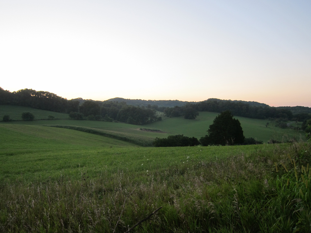
Drive across much of the upper Midwest and the landscape can feel broadly legible.
Rolling farmland.
Glacial lakes.
Broad low relief.
Then parts of southwestern Wisconsin, southeastern Minnesota, northeastern Iowa and northwestern Illinois become unexpectedly wrinkled.
Ridges.
Deep valleys.
Rocky bluffs.
Cold trout streams.
Narrow roads climbing and dropping through terrain that appears to have ignored the regional memo.
This is the Driftless Area.
The name is about what is missing.
Drift Means Glacial Debris
In older geological language, drift refers to sediment left by glaciers and glacial meltwater.
Till.
Sand.
Gravel.
Boulders.
Other material transported and deposited by ice.
The Driftless Area was named because large portions lack the direct glacial deposits found across surrounding landscapes.
The simplest popular explanation is:
The glaciers missed it.
This is broadly useful.
It is also incomplete.
The Ice Really Did Bypass Much of the Core
Southwestern Wisconsin provides the clearest example.
Wisconsin Department of Natural Resources material describes the region as bypassed by the major glacial advances that reshaped the rest of the state.
Without overriding ice to smooth hills and bury older valleys beneath thick drift, the region retained deeply dissected topography developed over very long periods of erosion.
Streams kept cutting downward.
Valleys remained narrow.
Ridges remained pronounced.
Then glaciers surrounded the region anyway.
This is where “missed” becomes misleading.
You Can Avoid Ice and Still Receive Its Mail
The Driftless Area was strongly affected by nearby glaciation.
Meltwater from surrounding ice sheets poured through river systems.
Glacial outwash—sand and gravel carried by meltwater—filled parts of major valleys.
Wind deposited loess.
Cold conditions shaped slope processes.
The Mississippi and Wisconsin river systems responded to enormous pulses of water and sediment.
Wisconsin DNR notes that glacial outwash filled parts of the Lower Wisconsin River valley to great depth, after which the river cut back down through those deposits.
So the region was not preserved under a dome while the Ice Age happened elsewhere.
It was unglaciated in the important direct sense.
It was still living beside a continent-scale ice machine.
Why the Terrain Looks Different
Much of the Driftless landscape developed in sedimentary bedrock.
Horizontal or gently layered sandstone, limestone and dolomite respond differently to erosion.
Streams cut valleys.
Harder layers form cliffs and ledges.
Softer layers weather back into slopes.
Over time, the result becomes a network of branching valleys separated by narrow ridges.
Geologists call this dendritic drainage because the stream pattern can resemble branching trees.
On a map, the landscape looks vascular.
From a road, it looks like someone forgot to flatten Wisconsin.
Karst Adds Another Layer
Limestone and dolomite can dissolve in slightly acidic groundwater.
That produces karst features such as caves, springs, sinkholes and disappearing streams.
Parts of the Driftless are strongly karstic.
This creates both beauty and vulnerability.
Groundwater can move quickly through cracks and solution channels.
Contaminants may travel with it.
Agriculture, wells, septic systems and groundwater protection become unusually connected to geology.
A landscape can look scenic and still be functioning as plumbing.
Cold Air Lives in the Rocks
One of the region’s strangest habitats occurs on certain rocky slopes.
Cold air can drain through fractured rock and emerge from openings at the base of slopes during warm months.
These are associated with features called algific talus slopes.
The result is a cool microclimate that can support species normally associated with much colder regions.
These habitats are rare and ecologically sensitive.
They make the Driftless feel like a geological loophole inside a geological loophole.
The glaciers did not cover the place.
Yet cold-climate species can persist in tiny refrigerated landscapes created by rock.
Trout Streams Make More Sense Now
Spring-fed streams are a defining feature of many Driftless valleys.
Groundwater emerging through limestone and other bedrock can keep streams cool.
That supports trout fisheries and specialized aquatic communities.
The same terrain that makes farming difficult on steep slopes makes water movement unusually visible.
Springs emerge.
Streams cut deeply.
Roads follow valley bottoms because the ridges are inconvenient.
Towns occupy narrow spaces between bluff and river.
Human geography begins following bedrock.
The Region Is Larger Than Wisconsin
Wisconsin owns much of the popular Driftless identity.
The region extends beyond the state.
The broad Driftless landscape reaches into Minnesota, Iowa and Illinois.
Definitions vary depending on whether the focus is geology, topography, ecology or tourism.
This is normal.
Natural regions rarely respect political boundaries perfectly.
The useful idea is the unglaciated or minimally glaciated core surrounded by landscapes more heavily modified by Pleistocene ice.
The exact edge gets messy.
Nature did not draw the tourism map.
Indigenous Homelands and Later Settlement
The Driftless is not merely an empty geological curiosity.
Indigenous peoples have long lived in and moved through the upper Mississippi region, including Ho-Chunk, Dakota and other nations with continuing cultural relationships to the landscape.
Later Euro-American settlement, mining, logging and agriculture transformed the region extensively.
Lead and zinc mining became especially important in parts of southwestern Wisconsin, Illinois and Iowa.
Today, ridges and valleys that look “natural” often contain deep histories of farming, grazing, extraction, settlement and restoration.
Geology is the stage.
Human history did not wait offstage.
The Glaciers “Missed” It
The phrase survives because it is good.
It explains the visual contrast quickly.
It also sounds like the Driftless Area got lucky by failing to attend the Ice Age.
The real history is more interesting.
Ice surrounded it.
Meltwater transformed major valleys.
Wind deposited sediment.
Cold altered slopes.
Rivers reorganized.
The region retained an older dissected landscape while receiving enormous secondary effects from glaciers nearby.
So yes.
The glaciers somehow missed it.
Then they spent thousands of years affecting it from the perimeter anyway.
The Midwest remains complicated.
Related: Michigan Has Enormous Sand Dunes Because the Great Lakes Are Showing Off · The Great Basin Is Hundreds of Basins and None of Them Know Where to Go · The Palouse Looks Fake
Leave a Reply