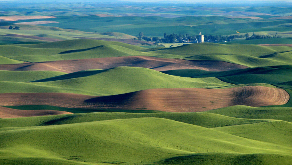
The Palouse of eastern Washington and northern Idaho looks like someone applied a smoothing tool to farmland.
Hill after hill rolls into the next.
There are few sharp edges.
Wheat fields bend over entire slopes.
Roads climb ridges that look soft enough to press with a thumb.
In late spring the whole landscape can turn an almost unreasonable green.
At harvest it becomes gold.
The hills look designed.
They are mostly windblown dust.
Loess Made the Surface
The defining soil material of the Palouse is loess.
Loess is fine silt transported and deposited by wind.
In the Palouse, repeated episodes of dust accumulation built remarkably thick deposits over older geology.
Washington State University and U.S. Geological Survey sources describe loess mantles tens of feet thick in places, with some deposits much deeper.
The smooth rolling topography we associate with the region is largely a landscape sculpted in these deep silts.
This is not sand-dune country in the ordinary sense.
The material is much finer.
Think dust.
Now think more dust.
Now continue for thousands of years.
Basalt Is Under There
Beneath much of the loess sits Columbia River Basalt.
Between roughly 17 and 6 million years ago, enormous lava flows spread across parts of the inland Northwest.
Layer after layer accumulated.
Later windblown sediment buried much of that dark volcanic foundation.
This gives the Palouse an excellent geological structure:
violent flood basalts underneath,
soft agricultural hills on top.
The landscape looks gentle because the top several yards are doing public relations for the lava.
Where Did the Dust Come From?
The Palouse loess accumulated over repeated episodes.
Sources included exposed sediments in the Columbia Basin and other glacial and flood-related deposits.
Wind carried fine particles eastward and northeastward.
Some research connects the youngest major loess layer to material redistributed after Ice Age floods and glacial processes.
Washington State University descriptions emphasize that the loess record contains multiple layers and buried ancient soils, or paleosols.
This means a Palouse hill can function like a layered archive:
dust,
soil,
dust,
soil,
more dust.
The hill is not one event.
It is repeated atmospheric delivery.
Why the Hills?
Wind deposition does not create an absolutely flat blanket.
Topography, vegetation and airflow influence where sediment accumulates.
Once rolling forms exist, deposition and erosion reinforce patterns.
The loess can become very thick over uplands and thinner in draws.
Streams cut into the landscape.
Agricultural erosion modifies it further.
The result is the famous rolling surface.
It can resemble dunes because wind built much of it.
But the soil is cohesive enough to support deep fertile agricultural profiles.
The Palouse is not a desert covered in wheat.
It is one of the world’s great loess landscapes.
The Soil Is Why the Wheat Is There
Deep silt-loam soils can hold moisture and nutrients extremely well.
That helped make the Palouse one of the most productive dryland grain-growing regions in the United States.
Wheat, barley, peas and lentils dominate large areas.
This agricultural productivity is not separate from the geology.
It is geology converted into farming.
Fine windblown sediment became soil.
Soil became grain.
Grain became elevators, rail lines, towns and an entire regional economy.
A Pleistocene dust problem eventually became bread.
Agriculture Also Exposed the Weakness
Loess is fertile.
It is also highly erodible.
The steep rolling slopes that make photographs beautiful create major soil-conservation challenges under cultivation.
Washington State University researchers have documented severe erosion in parts of the Palouse, including historical loss of feet of topsoil from some ridges and hilltops.
Tillage can move soil downhill.
Rain and snowmelt can carry exposed sediment away.
Once the richest surface layers are lost, less productive subsoil or buried paleosols can become exposed.
The fake-looking hills are real enough to lose themselves.
Native Palouse Prairie Is Now Rare
Before widespread Euro-American agricultural conversion, the region supported Palouse prairie dominated by native bunchgrasses and diverse flowering plants.
Only small remnants remain.
Washington State University conservation programs describe native Palouse prairie as one of the region’s most threatened ecosystems.
This creates a familiar environmental contradiction.
The deep soils that supported rich native grassland also made the land exceptionally attractive for agriculture.
Success in one system removed most of the other.
Modern restoration tries to preserve and rebuild fragments.
The hills remain.
The ecological cover changed almost completely.
Steptoes Break the Smoothness
Occasionally, older bedrock rises through the loess-covered landscape.
These isolated hard-rock hills are called steptoes, after Steptoe Butte in Washington.
They are older geological remnants surrounded by younger basalt and loess.
A steptoe looks like an island above softer terrain.
From the top of Steptoe Butte, the Palouse becomes almost abstract.
Curving fields repeat to the horizon.
Roads and property lines impose geometry on hills created by wind.
The landscape really does look rendered.
Why Photographers Love It
The hills amplify light.
Low sun creates alternating bands of brightness and shadow.
Agricultural patterns change color by season.
Long lenses compress the ridges and make them appear stacked.
Very little vertical clutter interrupts the forms.
This is why photographs of the Palouse can look less believable than the place itself.
The camera is not lying.
It is simply very pleased with the geometry.
The Land Is Not a Background
There is a danger in treating the Palouse as a visual pattern.
It is working land.
It is also habitat.
It contains soils vulnerable to erosion, streams affected by sediment, prairie remnants, wildlife, farms and communities.
Modern conservation practices including reduced tillage, no-till systems, cover crops and targeted erosion control attempt to maintain agricultural productivity without losing the soil that makes agriculture possible.
This is an unusually literal sustainability problem.
The resource being conserved is the ground.
Fake-Looking, Completely Real
The Palouse does not need one dramatic geological object.
No canyon.
No volcano dominating the skyline.
No giant rock.
Its weirdness is cumulative.
Millions of years of basalt.
Pleistocene wind.
Loess layered with ancient soils.
Streams.
Prairie.
Agriculture.
Erosion.
Then morning sunlight.
The landscape comes out looking too smooth to be natural and too large to be designed.
It is neither.
It is dust with excellent lighting.
Related: The Driftless Area: The Part of the Midwest the Glaciers Somehow Missed · Michigan Has Enormous Sand Dunes Because the Great Lakes Are Showing Off · The Great Basin Is Hundreds of Basins and None of Them Know Where to Go
Leave a Reply