Death Valley contains the lowest point in North America.
Badwater Basin sits 282 feet below sea level.
It receives very little rain.
Summer heat can become extreme enough to damage ordinary human thought.
The valley floor is famous for white salt flats stretching toward mountains.
Then, occasionally, enough rain falls that a lake appears.
This seems like the desert violating its job description.
It is actually the basin remembering what it is.
Badwater Is a Drain With No Outlet
Death Valley is part of the Basin and Range Province.
The valley floor has subsided along faults while surrounding mountain blocks rise.
Water flowing down from those mountains enters a closed basin.
There is no river carrying the water to the ocean.
Under normal modern conditions, evaporation wins quickly.
Water disappears.
Dissolved salts remain.
Over thousands of years, that process built the famous salt flats.
The dryness is real.
So is the drainage basin.
There Used to Be a Much Larger Lake
During wetter and cooler intervals of the Pleistocene, a large lake occupied Death Valley.
It is commonly called Lake Manly.
NPS describes the ancient lake as hundreds of feet deep during some phases.
The modern salt pan is part of the former lakebed.
Shoreline features and sediments record earlier water levels.
The desert floor is therefore not a place unexpectedly capable of holding water.
It is a place extremely well shaped to hold water but living under a climate that rarely provides enough.
The bowl remains.
The faucet changed.
Salt Is What the Lake Left Behind
A closed lake receives dissolved minerals from its watershed.
If water later evaporates without an outlet carrying those minerals away, the minerals concentrate.
Repeat for thousands of years.
Salt flats.
Badwater’s enormous white surface is largely sodium chloride mixed with other evaporite minerals.
Groundwater continues moving through the basin.
Evaporation pulls mineral-rich moisture toward the surface.
Salt crystallizes into polygonal patterns.
The valley is still processing water even when no obvious lake is visible.
Dryness is an active condition.
Then 2023 Happened
In August 2023, remnants of Hurricane Hilary produced extraordinary flooding in Death Valley.
Additional storms followed.
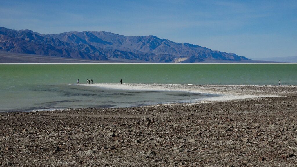
Water collected in Badwater Basin.
A shallow lake persisted far longer than visitors were accustomed to seeing.
By early 2024, people were kayaking on what had temporarily become a broad body of water.
NPS referred to it as Lake Manly after the ancient lake.
This was not the Pleistocene lake returning at full scale.
It was a modern temporary lake occupying part of the same basin.
Still:
Death Valley had kayaks.
No copywriter could improve the event.
Then the Lake Moved
In March 2024, strong winds pushed the shallow lake roughly two miles north.
NPS described it as a “traveling lake.”
The water level also dropped as wind increased evaporation.
Kayaking was discontinued to protect resources as the remaining water became shallower and shifted away from easy access.
This is what happens when a lake is only inches deep across a vast, nearly flat salt basin.
Wind becomes geography.
The shoreline can move dramatically without the amount of water changing nearly as dramatically.
Lake Manly did not drain.
It slid.
Flash Floods Are Not Contradictory in a Desert
Deserts can flood violently.
Dry ground may absorb water poorly during intense storms.
Steep mountains concentrate runoff.
Narrow canyons funnel flow.
Rain falling far from a visitor can create dangerous flooding downstream.
Death Valley roads and infrastructure have repeatedly been damaged by flash floods.
Aridity does not mean water never arrives.
It means water arrives infrequently enough that the landscape is often poorly buffered against sudden abundance.
A place can be one of the driest in North America and still have a water problem.
Sometimes the problem is almost none.
Sometimes it is several feet moving downhill at once.
The Mountains Feed the Basin
Badwater lies beneath high ranges.
Telescope Peak rises more than 11,000 feet above sea level a short horizontal distance away.
That relief matters.
Storms can drop rain and snow on mountains even when the valley floor remains comparatively dry.
Water then descends through canyons and alluvial fans toward the lowest basin.
Every drainage points toward the same conclusion.
Badwater.
The valley is an enormous collection system.
It just lacks the precipitation to keep the collection visible most years.
Climate Change Complicates the Extremes
A warmer climate increases evaporative demand.
It also changes precipitation patterns and can intensify some extreme rainfall events.
That does not mean Death Valley is becoming a lake again.
It means the hydrologic future can include both severe heat and damaging floods.
This is increasingly familiar across arid regions.
“Dry” does not mean “stable.”
A hotter atmosphere can produce a landscape simultaneously more drought-stressed and vulnerable to intense precipitation.
The desert may get drier in the long-term average while individual storms become more consequential.
Do Not Plan a Vacation Around the Lake
Temporary Lake Manly is not a permanent park feature.
The 2023–2024 event was exceptional.
As of current park guidance, boating and flotation devices are prohibited at Badwater Basin.
Visitors should not arrive expecting a repeat of viral photographs.
This is worth stating because extraordinary natural events quickly become tourism expectations.
The superbloom.
The lake.
The waterfall.
People see one image and turn a rare condition into an amenity.
Death Valley does not maintain the lake for guests.
The Lakebed Is Always There
The better way to understand Badwater is not:
Sometimes the desert becomes a lake.
It is:
The desert is a lake basin most of the time without enough surface water to look like one.
The salt tells you.
The flat floor tells you.
Ancient shorelines tell you.
Flood channels tell you.
Then, once every so often, rain makes the geometry obvious.
Water spreads across the basin.
Mountains reflect on the surface.
The driest famous place in America briefly produces a lake.
Then evaporation resumes its shift.
Related: Yellowstone Is Basically Plumbing · The Great Basin Is Hundreds of Basins and None of Them Know Where to Go · The Nebraska Sandhills Are a Desert Wearing Prairie
Leave a Reply